MMSU Used Satellite Imagery to Map Where Ilocos Region Should Be Making Salt. The Philippines Currently Imports 84% of What It Needs.
Two DOST-funded studies by Mariano Marcos State University, published in a Scopus-indexed conference in November 2025, used remote sensing and geospatial analysis to identify untapped saltern sites in Ilocos Region and quantify existing crystallization ponds in Pangasinan, building the data infrastructure for a national salt self-sufficiency push.
 Featured Partner
Inv8 Studio
Innovation Partner for Startups & Growing Businesses
Researchers from Mariano Marcos State University published two studies that use satellite data to answer a question the Philippines has been avoiding for decades: where exactly should the country be producing salt, and how much can each site yield? The papers, produced from 2023 to 2025 under MMSU's ASIN Project 1 with DOST funding, were presented at the 46th Asian Conference on Remote Sensing in Makassar, Indonesia in November 2025, and published as Scopus-indexed conference papers. Both studies are part of the broader Accelerating Salt Research and Innovation (ASIN) Program, a multi-university consortium involving MMSU, Pangasinan State University, Don Mariano Marcos Memorial State University, and President Ramon Magsaysay State University.
The problem these studies address is not abstract. The Philippines currently imports 84% of its annual salt requirements, down from 90% in 2022, but still one of the highest import dependency rates for a basic food commodity in Asia. The country has a long coastline. It has salt-producing traditions in Ilocos Norte, Pangasinan, and Mindoro that go back centuries. The gap between what the Philippines could produce and what it actually produces is a policy and infrastructure failure, not a geographic one.

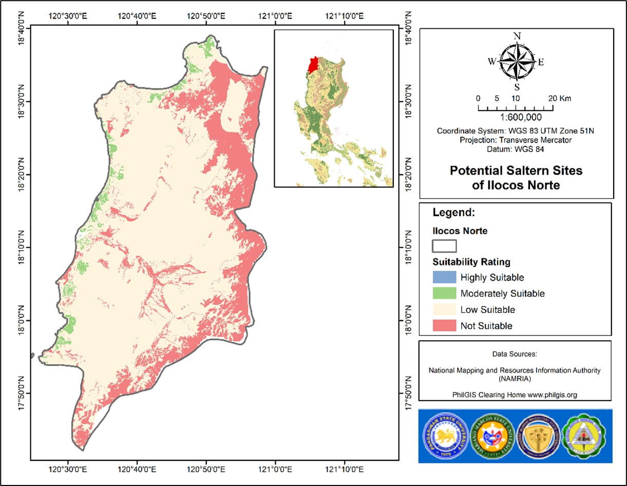
What the Two Studies Actually Did
The first paper, "Mapping Potential Saltern Areas Using Remote Sensing and Geospatial Analysis of Physical and Climatic Parameters for Sustainable and Innovative Salt Production," focused on identifying new sites across Ilocos Region with characteristics suitable for salt production. The research team, Dr. Rodel Utrera, Dr. Nathaniel Alibuyog, Engr. Julius Jonar Butay, Engr. Joemel Agreda, Engr. Nadine Sharinette Bravo, and Mr. Lord Ian Galano, analyzed land cover, topography, and weather data to classify potential saltern sites by suitability level. The result is a regional map of where new salt farms could be developed, ranked by viability.
The second paper, "Mapping and Classification of Crystallization Ponds in Pangasinan Salterns Using LandSat Imagery for Salt Production Estimation," took a different approach. Rather than identifying new sites, it measured what already exists. Using LandSat satellite imagery, the same team created a framework for estimating salt yield from existing crystallization ponds in Pangasinan, currently one of the country's most important salt-producing provinces, where Dasol and Bolinao alone produce approximately 18,000 metric tons annually from around 10,000 salt beds. The framework is designed to be replicated in any Philippine province with crystallization ponds.
Dr. Utrera summarized the intent directly: "These outputs help address gaps in data and salt productivity by using remote sensing tools. Our hope is that they will contribute to the enhancement of our nation's salt production and support a self-reliant salt industry."

The ASIN Programme Architecture
MMSU ASIN Project 1, led by Dr. Nathaniel Alibuyog, Vice President for Research Development and Innovation, is one of four component projects under the larger DOST-funded ASIN Programme. The multi-university structure is deliberate. PSU leads the Pangasinan production and innovation track, including the new ASIN Center at the Bolinao Salt Farm covering 473 hectares, formally advanced in February 2026. DMMMSU leads the Ilocos Norte modern production technology track, including high-density polyethylene-lined ponds and advanced filtration systems. MMSU leads the remote sensing and geospatial mapping track. Together, the four universities are building the data, technology, and institutional infrastructure for a national salt revival from Northern Luzon outward.
In November 2024, DOST Region 1 formalized this alignment through the OneASIN MOU, signed in Laoag City with MMSU, DMMMSU, BFAR Region 1, DTI Region 1, the Provincial Government of Ilocos Norte, and DOST-ITDI as co-signatories. MMSU's 2025 Scopus publication is the peer-reviewed scientific output that gives the OneASIN programme its evidence base.
What This Means for Northern Luzon
Northern Luzon holds most of the Philippines' remaining viable salt production territory. Pangasinan gave the country its name from the word "asin." Ilocos Norte's cooking salt tradition, while smaller in volume than saltern production, represents a distinct product category with heritage market potential. The MMSU remote sensing studies are the first systematic, satellite-validated effort to map where the region can grow its salt output, and to build a replicable framework for estimating that output before a single peso of farm investment is committed.
For entrepreneurs, agribusiness investors, and LGUs along the Ilocos coastline and Pangasinan's salt-producing municipalities, the MMSU suitability maps represent the clearest investment signal the salt industry has ever produced. A site classified as highly suitable by remote sensing analysis, cross-referenced against topographic and climatic data, is a fundable business case. The data now exists. The next step is connecting it to the MSMEs, cooperatives, and investors who can act on it.
MMSU ASIN Project 1 and the broader OneASIN programme can be reached through MMSU's Research Development and Innovation office or DOST Region 1 for collaboration and technical assistance inquiries.
Original Source:
Market Context:
The Philippines currently imports 84% of its annual salt requirements, down from 90% in 2022, with Australia and China as the primary suppliers. Philippine salt production peaked at 300,000 metric tons in 1994 before declining to less than half by 2010, driven by climate change vulnerability, land-use conversion, market competition, and food safety compliance costs. Pangasinan's Bolinao Salt Farm spans 473 hectares and is now the site of the new ASIN Center, supported by DOST and PSU, while Dasol and Bolinao together produce approximately 18,000 metric tons annually from around 10,000 crystallization ponds. The Ilocos Regional Development Council approved ₱141 million in proposed funding for salt research and development centers in the region, with ₱106.5 million from DOST and ₱34.5 million in counterpart funds, underscoring the scale of the national government's commitment to reviving the sector.
Are you a founder, innovator, or community builder in Northern Luzon?
We're always looking for compelling stories from the region's ecosystem. Whether you're launching a startup, running a program, or doing something interesting — we'd love to feature you.